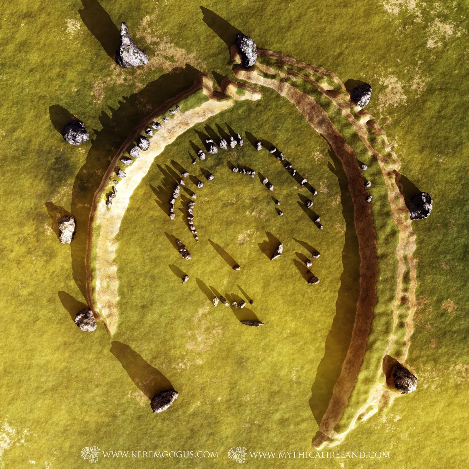
Monument was thought to have been completely destroyed some time between 1748 and 1907
However, some of its largest stones might have been buried
For years I have been drawing attention to a monument, sadly destroyed, which has been dubbed 'Ireland's Stonehenge'. This was a remarkable and unique monument consisting of several concentric circles of stone, surrounded by a large earthen embankment, all of which was encompassed by ten enormous monoliths.
Ireland's Stonehenge was documented by antiquarian and astronomer Thomas Wright in 1748. His drawing is the only known representation of this once great monument, which was located in a townland known today as Carn Beg, not far from the town of Dundalk, in the north of County Louth. I first wrote about Ireland's Stonehenge in 'Island of the Setting Sun' in 2006.
This huge monument vanished from existence some time between Wright's drawing and brief description of it in 'Louthiana' (1748) and the construction of the Drogheda to Portadown section of the Dublin-Belfast railway line in 1855. Historian Henry Morris, writing for the County Louth Archaeological Journal (CLAJ) in 1907, gave us a tantalising insight into what the monument's purpose might have been when he wrote: "I have read or heard it stated somewhere that this place was the site of a school of astronomy. Its position on the plain, with a semicircle of mountains around would enable an ancient astronomer to observe and mark the places where the various heavenly bodies appeared on the horizon at different times of the year." Regrettably, Morris was unable to recall the source of this valuable detail.
 |
| Wright's all-too-brief description of this remarkable monument, from Louthiana. |
Not long after Wright's drawing was published, the Armagh Road was built, probably in the 1750s, and there can be no doubt that this was a significant factor in the destruction of the stone henge. I
overlaid Wright's drawing of the monument on to Google Earth imagery of the site and this makes it obvious that at least some of the monument was flattened for the purpose of the new road.
 |
A crop mark of the monument on
a CUCAP photo from 1970. |
I remember reading somewhere (although I cannot now recall the source) that the smaller stones were taken away and either broken up to be used as foundation material for roads, or were used as gate posts. Henry Morris could find no remains of the monument in 1907, saying that it was "Gone! Cleared away, its very site not exactly known". (For much more information, and sources, see
Island of the Setting Sun - In Search of Ireland's Ancient Astronomers, chapter 5, 'The Giant Rings'.)
It wasn't until 1988 that the exact location of Wright's druidic temple was finally rediscovered. Archaeologist Victor Buckley was able to discern the monument's "footprint" in an aerial photograph which had been taken in 1970 for the Cambridge University Collection of Aerial Photographs.
There was some archaeological resistivity was carried out at the site in 2006, in advance of a proposed housing development which never happened once the Irish economy collapsed. Standing at the site, which is now part of a disused golf course attached to a hotel, it is very difficult to get any sense that it was anything other than a field. There are simply no stones remaining. None.
However, I've recently discovered something significant about what might have happened to the large stones - or at least some of them - in the most unlikely of sources.
Reading George Henry Bassett's 'Louth County Guide and Directory (1886), we find that early on, he makes reference to the area's antiquities:
The remains of antiquity are very numerous, and extend through every part of the county. They continue in very much the same condition that they were found more than one hundred and twenty-five years ago by Thomas Wright, author of Louthiana. His work was instrumental in stimulating the curiosity of many of the residents of the county in regard to the precise nature of the contents of the Danish and Irish forts and Druidical camps.
 |
In this work in progress, digital artist Kerem Gogus has fantastically recreated
Ireland's Stonehenge in 3D based on Thomas Wright's 1748 drawing. |
And here comes the most valuable information pertaining to what happened this once marvellous monument:
It had not the effect, however, of preventing a tenant, near Dundalk. from effacing the Druidical circle at Ballynahatna. Of the ten stones which were said to represent the generations from Adam to Noah, only one now stands in the original position. Most of the rest were dropped into holes sunk behind them, and covered at a sufficient depth to escape the plough.
This is most interesting. Bassett says that instead of bring broken up, like the smaller stones, the large ones were dropped into huge holes to bury them. This is quite exciting as it leads to the possibility that at least some of these large megaliths are still there - buried where they once stood. Perhaps this is information which might lead archaeologists towards further investigation of the site at Carnbeg?
Further reading:
Ireland's Stonehenge
Note: I am indebted to Kerem Gogus, the 3D artist, for all the effort he put in to recreating Ireland's Stonehenge so that we might get a better sense of what it looked like. Visit his website here:
http://keremgogus.com/