Many people look for meaning in the symbols carved in stone at the great monuments of the Boyne. Sometimes the most facile examination (and perhaps the most puerile too!) is to indulge in pareidolia. When I took this image at Knowth/Cnogba today, I was conscious of the image of the Cailleach, having been reading about her quite a lot lately. I will quote the lovely words of the late Patricia Monaghan, whose book 'The Red-Haired Girl From the Bog' I am currently reading:
"Rock is the hag's prime element, her stony spine.... Cailleach time moves form moon to moon, harvest to harvest. It is pagan time, rooted in the eternal return rather than the once-off redemption."
Seeing this stone again – known under the archaeologists’ counting system simply as Kerb 22 – I was struck at how much it seemed to look like a big smiling face with two bulbous eyes and a big, broad grin.
These rocks were already eternally old when they were hauled into place - all 127 of them - to create a giant kerb or belt of stones around the gigantic mound that we know as Knowth. And now the carvings that were carefully etched into the surface of these slabs are eternally old, and the rocks that bear them speak of the beginning of time.
Once upon a time, so the story goes, this great mound of stone and earth was known as Cnoc Búa or Cnoc Buí, the hill of the daughter of "red-haired Rúadrí", wife of Lug, son of Cian, of the ruddy spears.
"It is there [Cnogba] her body was buried; over her was built a great hill."
What shall we say about Buí today, except that she is remembered still, in these many aeons since her image was first conceived in stone, at the mighty Brug na Bóinde where the hag never dies. The hag's breasts are imagined as mounds in the Boyne landscape; her passage-wombs, creaking and groaning under the weight of the ages, live on to tell the story of the undying sons who were born there – Oengus the young, who was conceived and born in the same day; and Sétanta, whose crossing of the threshold of initiation brought him from innocent boy to murderous warrior. In there, Elcmar the magician of Brug na Bóinde, divined souls with his fork of white hazel; Dagda Mór, the Eochaidh All-Father, offered satiation to those who were crossing over; Oengus protected the beautiful Etaín from the jealous Fuamnach in his sunny, crystal bower.
At ancient Cnogba, it is said that Englec the daughter of Elcmar was stolen away by Midir, much to the heartache of her lover, Oengus Óg. At Newgrange, Oengus had protected Midir’s lover Etáin, and yet at Knowth the two were love rivals for the woman Englec, whose disappearance was mourned greatly by the inconsolable Oengus. Mourning the abduction of his beloved, Oengus engaged in a curious ritual … casting the “blood-red nuts of the forest” on to the ground, and performed “a lament around the little hill”.
Cnogba (Knowth) commemorates a goddess Buí and a goddess Englec.
And so, in the confusion of tales so typical of the lore of the olden days, Knowth commemorates two distinct but perhaps not mutually exclusive events – both involving the passing (so to speak) of great women (goddesses even). As Cnoc Buí, Knowth remembers the great woman who was set to rest there beneath its heaving bulk, the undying hag of the ancient world who had many names and guises. As Chnó-guba (the “nut-lament”), Knowth commemorates the passing of Englec into another realm, swept away by Midir to the Síd of Fer Femin, never to be seen by Oengus again.
Today, I stopped in front of stone 22 at Knowth during my round of the kerb (deiseal, sunwise, this time), and, having to stall a while under the modern concrete ledge to shelter from a summer shower, I imagined for a time that I was seeing the great women of Cnogba, the abiding visage of the ancient hag that was known here as Buí, and the darling Englec, the beautiful daughter of Elcmar. And I wonder which would endure longer – the memory of these great mythic women, or the stone carvings bearing this image.
I was very fortunate to have been given an opportunity to see and photograph an enigmatic and fascinating relic of Ireland's past in recent days. I had long known that once upon a time there was a Sheela-na-gig built into the wall of the old mill house at Rosnaree on southern bank of the River Boyne.
An old photo showing the Sheela-na-gig in place in the wall of the mill. Photo courtesy Barbara Heise.
About quarter of a century ago the ancient stone-carved figure was removed from its place in the wall of the mill for safekeeping. Before that, it had been whitewashed over so many times that it was becoming difficult to see its features.
The owners of the old mill, Georg and Barbara Heise, beautifully and lovingly converted the old structure into a modern habitable home. I was delighted to be given an opportunity by the Heise family to examine and indeed take photos of the Sheela-na-gig.
You might ask what a Sheela-na-gig is. They are "female exhibitionist carvings found on walls,
abbeys, convents, churches, pillars and other structures in Ireland,
England, Scotland and Wales, as well as in other parts of Europe. They
come in many different shapes and sizes, but all share the same
characteristic of a prominent and often enlarged genitals, often held
open by the figure's hands. Most date from the middle ages."(1)
There are various theories as to what their intended meaning or purpose was, but we simply don't know for sure. Some suggest they were fertility figures, and that touching them was considered a blessing for assured pregnancy. Others say the fact they were often positioned on the walls of churches meant they served as a grotesque warning against the "sins of the flesh". Is the Sheela-na-gig supposed to represent a goddess? Or a crone/hag, like the cailleach?
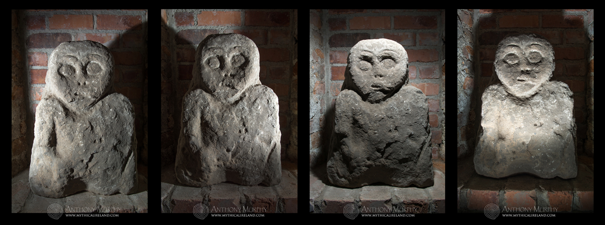
Anyway, regardless of the theories, they are indeed fascinating. Here is a montage of photos I took of the Rosnaree Sheela. In order to capture as much of the detail as possible, I used a remote flash and illuminated the figure from left, right, above and below. Click the image to see a larger version.
Four views of the Sheela-na-gig, illuminated from the left, right, above and below.
Here's a description from the Sites and Monuments Record (SMR) taken from the Archaeological Inventory of County Meath: "Sheela-na-gig now in private possession. Figure formerly built into wall
beside door of mill that was not its original location. Removed from
wall of mill and kept safe in store. Described by Freitag as a figure,
‘crudely carved on irregular stone slab; widest at bottom part which is
cut straight, allowing figure to sit firmly on ground. Elongated, deeply
hollowed out groove in crown of head (presumably for libations) further
indication of figure originally free-standing. Left side defaced, and
some damage also to chin, right forearm, right foot and lower part of
leg. Large head, no ears, big owl-like eyes with eyebrows, clearly
marked nostrils, jagged incision indicating mouth and possibly teeth.
Four striations on right cheek running down to side of slab. No neck or
breasts, but clearly marked navel. Right arm reaches under leg which is
widely splayed, but no hands or fingers traceable. Genitals indicated by
deep semi-circular depression’ (Freitag 2004, 140)."(2)
Recently, a link has been suggested between these grotesque Sheela-na-gig figures and the wife of Saint Patrick, who was called Sheela. The scholar who suggested that link, UCC folklorist Shane Lehane, says the following of the Sheela-na-gigs:
Sheela-na-Gig is a basic medieval carving of a woman exposing her
genitalia. These images are often considered to be quite grotesque. They
are quite shocking when you see them first. Now we look at them very
much as examples of old women showing young women how to give birth.
They are vernacular folk deities associated with pregnancy and birth.
I wish to express my thanks again to the Heise family for making me so welcome and for allowing me the opportunity to see this rare and fascinating relic of the past.
A photo of the old mill house at Rosnaree during winter floods a few years ago.
In honour of Sheelah, whose special day is today, I've written this
poem. The photo is of Newgrange at sunset a couple of weeks ago. It is
my 200th upload to the Newgrange gallery.
Síd in Broga (Newgrange - the 'Big Sidhe!') under a red sky at sunset.
THE BIG SIDHE
What is the Síd/Sidhe/Shee? Shall we go and shee? No, you cannot see the shee. The shee is for Sheelah. Who is Sheelah? She is the woman who cannot be forgotten. She is the great mystery.
So what is the shee?
Is it a fairy palace?
The shee is more than that.
The shee is the great mystery.
It is the untranslatable concept.
Untranslatable?
Yes. You call Síd in Broga by this strange name, The New Grange
And the gods shudder.
Síd in Broga will not reveal
her mysteries in a strange tongue.
There are no words
that will introduce you to her.
Sheelah of the great sidhe.
She is the unknowable,
except through symbol.
The symbol of the sidhe.
This is the so-called Hag's Chair at Cairn T, Sliabh na Calliagh, Loughcrew. Although it is part of the kerb of the cairn, it is unlike any other kerb stone on any Irish passage-tomb. We know very little about it, except what myth and folklore offer by way of mysterious and vague explanation.
Amid all the more modern graffiti, some of the really ancient carvings can still be seen on the Hag's Chair.
The Cailleach (or hag/witch/crone/goddess) of Loughcrew is ubiquitous on these hills. The story of the cairns is the story of this ancient figure of mythical intrigue. The creation myth of Loughcrew (for that is how it can be best described) suggests that she built the cairns, somewhat haphazardly, by dropping stones from an apron of stones as she jumped from hill to hill. She is said to have come from the north, which is interesting, because towards the northern aspect we find the rounded mountain of Slieve Gullion in Armagh - another place associated with the Cailleach (who goes by different names) and has a passage-tomb on its top which has a passage that points towards Loughcrew for winter solstice sunset.
"This is a very old lady whose shade still haunts the lake and carn of Slieve Guillion in the county of Armagh. Her name was Evlin, and it would appear from some legends about her that she was of De Danannite origin.... Does her name, Eibhlín bheurtha inghin Thuilinn, appear in the genealogies of the Tuatha De Dananns?"(1)
Cairn T at Loughcrew, also known as The Hag's Cairn.
Some sources suggest that the ancient Cailleach might have been the Queen Tailte(2), in whose honour the Tailteann Games were held at nearby Teltown. As the Cailleach Bhéartha, she is the one who brought the cairns into existence, but not untypical of such creation myths, she is killed in the effort:
There are three hills about a mile asunder in this parish, having three heaps (carns) of stones on their summits, with which the following wild legend is connected. A famous old Hag of antiquity called Cailleach Bhéartha (Calliagh Vera) came one time from the north to perform a magical feat in this neighbourhood by which she was to obtain great power if she succeeded. She took an Apron-full of stones and dropped a carn on Carnbane; from this she jumped to the summit of Slieve Nacally a mile distant and dropped a second carn there; from this hill she made a second jump and dropped a carn on another hill about a mile distant. If she could make another leap and drop the fourth carn it appears that the magical feat would be accomplished, but in giving the jump she slipped and fell in the townland of Patrickstown in the parish of Diamor, where she broke her neck. Here she was buried and her grave was to be seen not many years ago in a field called Cul a' Mhóta about 200 perches to the East of the moat in that Townland, but it is now destroyed.(3)
I speculate here that the second part of her name, Bhéartha/Vera possibly derives from the Irish word bert or beirt, meaning "burden, load, bundle".(4)
It's interesting that she has several different names - Cailleach Bhéartha (Cally Vera), Evlin (Eibhlín), Garvoge and even Tailte. The hills also go by different names. Carnbane (carn bán) is the one we know today as Carnbane West. In one version, it is called Carnmore (from carn mór, the big cairn). Indeed, the largest cairn in the whole Loughcrew complex, Cairn D, is on Carnbane West. Carrigbrack, which does not feature in some versions of the creation myth, is from carraig (stone) and breac (speckled), thus "speckled rock", but is also known as Sliabh Rua (Red Mountain), for which there is a very obvious and fascinating astronomical reason connected with local alignments. Sliabh na Calliagh (also anglicised as Slieve Nacally) is, apparently, also known as Carnbeg (carn beag, the small carn). Although because there is a middle hill called Loar, one wonders if Loar was Carrigbrack or Carnbane East, possibly making Patrickstown Hill the Carnbeg of the variant. More research needed here I think!
Sliabh na Calliagh, crowned by the Hag's Cairn, in the dawn sky, viewed from Carnbane.
Wont as I am to engage in speculation, I have often wondered if the story of the old hag dropping stones as she leaped from hill to hill is not in fact related to the movements of the sun, moon and the stars somehow. We know that several cairns point to other cairns (Cairn L points to the cairn on Carrigbrack, for instance; Cairn I points to Cairn T, etc). Is the cailleach the moon? We know from research into the Boyne Valley monuments that Venus (the Morning Star) was known as caillichín na mochóirighe, meaning "early-rising little hag"(5). It is tempting indeed to view the moon, with its darker areas, as an apron or bag full of stones. As she drops the stones, the moon becomes smaller, until it fades to a slender crescent into the growing light of morning, before eventually disappearing (in the east) as the dawn comes.
It is possible also that the cairns might mark out various important lunar risings and settings which mark out its course through the sky during the 18.6-year rotation of its nodes. Observation of this cycle leads to the observation of lunar standstills and the prediction of lunar eclipses. Martin Brennan and his team of researchers (including Jack Roberts) made several important discoveries at Loughcrew in the 1980s, showing certain astronomical alignments. They made several observations of lunar events. It would be nice if this work was followed up. In the fullness of time, a greater story about the astronomical complexity of Loughcrew might emerge. And, perhaps, a "solution" that cracks the meaning of the myth of the Cally Vera.
Until then, we can only suggest that some day this ancient queen might return, and claim her throne once more.
References (1) Conwell, Eugene, On Ancient Sepulchral Cairns on the Loughcrew Hills, Proceedings of the Royal Irish Academy Vol. 9, p.357. (2) For instance, http://www.duchas.ie/en/cbes/5070784/5063151/5095468 (3) From John O'Donovan's Ordnance Survey Letters (Meath). (4) Dil.ie (5) Murphy & Moore (2006), Island of the Setting Sun, p.167.
Many of you have probably heard the story of the Cailleach (hag or witch) of Loughcrew. The hills of Loughcrew are scattered with the remnants of a vast cluster of megalithic monuments that are thought to be up to 5,500 years old. There are four hills - all containing monuments, mostly megalithic cairns and passage-tombs. These are known today as Carnbane West, Carrickbrack, Carnbane East and Patrickstown Hill. The hills, three of them at least, were collectively known in the 19th century as 'The Witches Hops', and in the 17th as 'the Calliagh Steppes'. In some versions, Carrickbrack is omitted, and in the 15th century the remaining three were referred to as Trí Choiscéim na Caillighe, the three footsteps of the hag.
Climbing Carnbane East to see Cairn T, with (in the left background) Carrickbrack and Carnbane West.
There is an old poem told about the Cailleach of Loughcrew, that goes like this:
I am the Chailleach Beara
Many wonders have I seen
I have seen Carn Bawn a lake,
though tis now a mountain green. (1)
The story about the Cailleach tells how she came from the north and she tried to jump from hill to hill, some say from the Carnbane (the westernmost hill) to Patrickstown (the easternmost), alighting on the other hills in between. If she could succeed in this magical feat she would obtain great power. She was carrying an apron full of stones. As she jumped from hill to hill, she dropped some stones from her apron, forming the cairns on each of the peaks. When she reached Patrickstown (which is undoubtedly a Christian name, and perhaps we might some day learn what its original name was) she fell and broke her neck. According to Jean McMann, in her lovely little book Loughcrew - The Cairns - A Guide, a pile of stones at the bottom of the eastern slope of Patrickstown Hill was known until recently as the cailleach's grave.
In earlier times the hill we know today as Carnbane West was known just as the Carnbane (Carn Bán, the white cairn or the white heap of stones). The hill known today as Carnbane East was, it seems, known as Sliabh na Caillaigh, the mountain or hill of the hag/witch.
Cairn T on Carnbane East, formerly known as the Hag's Carn and Sliabh na Caillaigh.
There is no doubt in my mind that the story of the Cailleach of Loughcrew contains essences of an ancient creation or origin myth. This great woman, whose status has been reduced to an old crone, was probably a goddess of the land who was greatly venerated in ancient times. McMann says of her:
'This cailleach is famous in Irish folklore. Other storytellers have described her as a superhuman woman who could harvest a field faster than any man, a crone lamenting her youth, a banshee announcing a death, or a Christian nun. She is best known as Cailleach Bhéarra, but has been called by many other names, including not only Waura but Beri, Buí and Vera ... and may be a later version of the ancient pagan sovereignty queens whose consent was required for kings to rule. Some scholars think she represented wild nature, as a prehistoric earth goddess'.
Michael Dames, writing in 'Ireland, A Sacred Journey', suggests that "the apron is the divine womb, translated into the language of dress".
In this context, we can see the apron as a womb of creation, and perhaps, in the tradition of Marija Gimbutas, we can think of the cairns not so much as tombs, but more like wombs. As a creation or origin myth, the story of the Cailleach of Loughcrew shares some similarities with another origin myth, that which tells about how the River Boyne was formed. In that story, Bóinn approaches Nechtain's Well, something which is forbidden for a woman. The well gushes forth into a fountain, carrying Bóinn along as it creates the River Boyne. Bóinn is mutilated by the waters - she loses an eye, and her arm and leg are broken. Eventually, she is washed out to sea, where she is drowned. Her lapdog, Dabilla, is transformed into the Rockabill islands. In both cases, a female deity is credited with an act of creation, and in both cases at the end of the act of creation the women are killed.
But there is more to the story of the Cailleach of Loughcrew than meets the eye. I'm inclined to think that the imagery of a woman jumping from hill to hill forming cairns is, perhaps, some memory of an ancient astronomical system in which the sun and moon were seen to rise up out of various hills and cairns when viewed from other parts of the complex, and conversely they were seen to "set into" hills and cairns from other vantage points. I'm inspired in this aspect by the Cailleach na Mointeach, the "Old Woman of the Moors" at the Callanish stones in Scotland. The local people there refer to her as the "sleeping beauty" and once every 18.6 years, the moon at its major standstill southern extreme rises from some part of this sleeping beauty and sets again at the bottom of Mount Clisham. (2)
Until 1980, little was known about any astronomical aspect of the Loughcrew cairns. But in that year, Martin Brennan and Jack Roberts discovered the equinox alignment of Cairn T, during which the light of the rising sun on the equinoxes shines into Cairn T (photographed on left) and illuminates what Brennan described as "solar emblems" on the stone at the rear of the chamber. They also discovered that the chamber of Cairn L appeared to be aligned towards the November and February cross-quarter sunrises, and several other small cairns appeared to have alignments towards solar events. In some cases, the passage of a cairn is pointing towards another cairn. For instance, from the chamber of Cairn I on Carnbane West, the sun appears to rise over Cairn T on Carnbane East at the beginning of September.
The imagery of a woman, or goddess, jumping from hill to hill is, I think, possibly symbolic of a system of alignments from various parts of the megalithic complex, focusing on sunrises and moonrises, and also sunsets and moonsets. In the fullness of time, I think an even more comprehensive study of the alignments of Loughcrew will reveal an interest in the extreme lunar declinations, the minor and major standstills of the moon. At Dowth, for instance, my own studies of the alignments of its two known passageways indicates that the setting moon at both its major and minor southern setting positions might have been the primary, or even shared, targets of the southern and northern chambers, while the setting sun at winter solstice (southern chamber) and November/February cross-quarter days (northern chamber) were also targets. Perhaps the death of the Cailleach is allegorical, referring to the lunar extreme, and perhaps the "death" of one 18.6-year cycle and the beginning of the next one? The fact that she was said to have "come from the north is also interesting, because of the fact that the maximum northern rising and setting extremes of the standstill moon are located in the far northeast and northwest.
Until a more comprehensive study of possible lunar alignments at Loughcrew can be undertaken (and I must admit I would be very happy to be involved!) we can only reflect on the possibilities. We know that there are certainly solar alignments. We can't be sure that these alignments were an intended principal function of the monuments, but they constitute a fascinating and indeed almost mystical aspect of these ancient structures. To be lucky enough to have been witness to some of these alignments makes me feel an extraordinary connection with the builders.
We cannot know how far back the story of the Cailleach of Loughcrew goes. Certainly as Jean McMann acknowledges, "People have probably been telling stories about the Loughcrew hills for more than five thousand years".
Is it too bold a step, to wild a conjecture, to suggest that the story of the Witches Hops or the Cailleach's Steps is in fact some remnant of a very ancient myth, one which goes right back to the time when these cairns were constructed?
The illumination of solar emblems by equinox sunrise at Cairn T.
Addendum - watching the moon
Of interest to our discussion about lunar standstills at Loughcrew is the fact that a society carefully observing and recording the moon's cycles would become aware of several things. The number of sidereal months (the time it takes the moon to complete a circuit of the sky, ie from a particular place on the Zodiac back to the same place again) and synodic months (a particular phase back to same phase, eg full moon back to full moon) does not fit neatly into a solar year. 12 synodic months is 11 days short of a 365-day solar year. In fact, the number of lunations only fits the solar year after 254 sideral months, or 235 sidereal months, which is equal to 19 years. This 19-year cycle is known today as the Metonic Cycle. See this page for a further discussion of the Metonics.
Observers watching the Metonic Cycle would also naturally become aware of the rotation of the moon's nodes, and 18.6-year cycle during which the point where the moon's path crosses the sun's path (the moon's path is inclined to the ecliptic by 5.15 degrees, so its path intersects the sun's path at two points in the sky each month) appears to complete a full circuit of the sky. As this happens, the moon appears, at certain times during this 18.6-year cycle, to go through maximum and minimum extremes, which are observable by the moon's rising and setting places relative to the sun's solstice positions. When the moon's node is located exactly on the sun's solstice positions, there is a likelihood of eclipses occurring at the time of the solstices. Conversely, when the moon's nodes are located exactly on the sun's equinox points, not only is there a likelihood of eclipses at the time of equinox, but the moon's path will be at its maximum separation from the ecliptic at the sun's solstice positions. If the moon's declination is at that time within the range of the sun's path, we get what is termed the "minor standstill", while if its declination is outside of the sun's range, we get the major standstill.
It is possible the builders of Cairn T at Loughcrew were not exclusively focused on the equinox sunrises, but also on observing the moon, and in particular at those times when its node was crossing the ecliptic at the sun's equinox points. If this is the case, as we can merely speculate, then we can envisage observers within the rear recess of Cairn T watching for the rising moon at such times. The natural extension of this argument is that if the moon is visible through the aperture of Cairn T and is in the same position in the sky as the equinox sun*, then seven days later (i.e. one-quarter of a circuit around the sky), the moon will be at its major standstill rising position (provided it is on its ascending node when visible within Cairn T) or at its minor standstill rising position if it is on a descending node. In other words, the Hag's Cairn might have been used to indicate the times of the extremes of the moon, when an 18.6-year cycle was ending (the death of the hag?) and a new one was beginning.
(* Around the time the cairns were built. the spring equinox sun was positioned in the constellation we know today as Taurus, the bull, while autumn equinox sun was positioned in Scorpius.)
When you stand at the giant amphitheatre-like henge monument near Dowth - the one archaeologists have ingloriously named 'Site Q' - on the morning of summer solstice, the longest day of the year, you will see the sun rising out of the landscape towards the northeast near Castlecoo Hill, at Clogherhead. Site Q has two large openings, one at its south western end, and one at the north east, which both appear to line up towards the solstice sunrise position.
Site Q, the giant henge of Dowth.
The name Castlecoo comes from Caisleáin Có, meaning the "stone fort of the hound", a possible explanation for which is given in 'Island of the Setting Sun' (2006, 2008 by Richard Moore and I). But another townland name on the hill of Castlecoo has long piqued my interest.
That townland is Callystown, which has generally been translated as Baile na gCailleach, the "town of the nuns". Tradition says that there was once a nunnery at Callystown, hence the name. But the issue is not as straightforward as that. The Cailleach was an ancient goddess, revered in prehistoric Ireland in places far and wide. She was known in some places as the Cailleach Bheara / Cally Vera, and although long since reduced to the paltry stature of a "hag" or "crone", it seems that at one time she was a female deity held in very high esteem. Indeed I would draw comparisons between the great Cailleach and goddesses such as Bóann and maybe Brigid, but I will save that for another day.
We know that the Cailleach was revered in this region in ancient times. The hills of Loughcrew, upon which sit ancient passage-cairns that are older than Newgrange, Knowth and Dowth, are called Sliabh na Caillighe - the hills of the witch/hag/crone/old woman. She is said to have formed the cairns upon Carnbane East and Carnbane West as she jumped from peak to peak, carrying an apron full of stones, some of which she dropped as she jumped. Curiously, the same story describes the construction of the round tower at Monasterboice in County Louth. According to folk tradition, gathered in the Schools Folklore Collection, the round tower was formed by the Cailleach dropping stones from her apron. In one version of the tale, the Cailleach becomes the Virgin Mary. In another version, she slips from the top of the tower and is killed in the fall to the ground. Not too far away is a stone age wedge tomb called the "Cailleach Bhirra's House". Monasterboice is only six or seven miles west of Clogherhead.
I've long wondered if the Callystown area of Clogherhead was perhaps named more anciently than the arrival of the nuns. Richard and I made a strong case in Island of the Setting Sun for a link between the goddess Bóann and the Moon and Milky Way. Similar connections could be made with the Cailleach, who was venerated all over Ireland and whose name survives in many townlands and even on the Beara Peninsula in Cork, along Ireland's southern extremity.
Thanks to the widespread availability of historical sources on the internet, it now seems as though I've been able to answer that question, or at the very least to throw some doubt and intrigue on the matter. According to an article on the history of the 'Ancient Parish of Clogher and Kilclogher' on the Clogherhead Development Group website, the nuns arrived in Callystown at the turn of the Sixteenth Century.
Writing in 2003, Liam Mac Raghnaill said: "In 1508, a small community of nuns, known as the Black Nuns, arrived at Callystown, where they held 128-acres, a cottage and possibly a small church. They are believed to have moved from Termonfeckin to Callystown as a result of a dispute with the Lord Primate of the time. The convent buildings were thought to have been situated near to the site where Callystown House was later built, but no trace remains."
The case would appear to be closed. Clogherhead's Callystown is so called because the Black Nuns lived there from the Sixteenth Century. However, I decided to reference the Online Placename Database of Ireland (Logainm.ie) to see what further information, if any was available, could be gleaned about this place name.
Callystown and Castlecoe Hill on Google Maps.
Imagine my surprise then, upon browsing the archival records about Callystown, to see that it appears to have been called Callystown before the nuns ever arrived there! In fact, the earliest record, going back all the way to 1301, suggests it had that name a whole two centuries before the nuns came along. As with most place names, the spelling varied throughout history, but it seems that it was known in some form as Callystown in the years and centuries before the nunnery existed there. Here are the various spellings of the place name down through history:
This last spelling, the one immediately preceding the arrival of the nuns, is almost definitely a rendition 'Cailleach' or 'Cailliagh' and 'town'. So there was a nun in Callystown before the nuns! Or, at least, a hag/crone/ancient goddess - call her what you will.
Because of the prominent position of Callystown/Castlecoo Hill as a horizon "marker" for summer sunrise from the great Boyne Valley monuments, and because of the very strong association of those monuments and their river valley with the goddess Bóann, it should be possible to at least re-consider the origin of Callystown, and to acknowledge the possibility of another inception for its name.
It is, of course, still possible that there was some sort of nunnery or convent at Callystown before the arrival of the Black Nuns. Interestingly, there is a place at nearby Termonfeckin called 'Nunneryland', and we were told the old Irish name for that place was 'Cailleach Dubh', possibly meaning 'Black Nun'. Because Cailleach also means "veiled one", there is a tendency to associate the word with nuns. But as previously stated, the Cailleach is one of Ireland's most ancient divinities. Cailleach Dubh can also refer to the cormorant (a bird), but in her guise as a goddess, the Cailleach Dubh is found even in Scotland.
Local tradition in Termonkfecin suggested that there was once an old laneway that ran all the way from Nunneryland to Callystown. Declan Quaile, writing about the old townlands and placenames of the area, said that: "Callystown was always pronounced ‘Calliaghstown’ by the old people, harking back to the original Irish word." Wikipedia has some interesting information about the Cailleach.
What might be even more fascinating about the apparent connection between Callystown and the Brú na Bóinne monuments is that the hill doesn't precisely mark sunrise on summer solstice, but is probably a more comfortable fit with the rising of the full moon at the time of its northern extreme. Did the ancient monument builders of the Boyne once upon a time see the full moon rising out of Castlecoo Hill at a significant astronomical moment, and did they then name that sacred hill in honour of the great goddess of creation? We might never know, but we can speculate . . .
I'm very excited about the forthcoming launch of 'Slí Bhríde' - Brigid's Way - a Celtic Pilgrimage route based on an alignment of prehistoric and eminent sites and monuments linking the two places most strongly associated with Brigid - the Saint and the Goddess - Faughart and Kildare.
An image of the Slí Bhríde from Google Earth showing the sites along the alignment.
The new pilgrim route is inspired by an alignment which was initially discovered a decade ago when Richard Moore and I found that the Hill of Tara, the Hill of Slane and the Mount Oriel barrow cluster were perfectly aligned. We furthermore realised that, at the moment Saint Patrick lit the Paschal Fire, at dusk on March 26th 433AD, an incredible cosmic event was happening in the sky over Slane. With the eyes of the High King, Laoghaire, and his subjects drawn from Tara towards Slane, Patrick lit a huge fire just as the cross-shaped constellation Cygnus was rising over Slane, with the centre star of the cross, today called Sadr, directly in line with the fire. The cosmic symbolism of that moment was incredible. The ancient and sacred cross of old Ireland, present in Newgrange and other prehistoric sites, was being replaced with a new cross, the cross of the new religion, brought from distant lands. But the alignment must have been prehistoric and pre-dated Patrick possibly by three millennia or more. The Hill of Tara is at least Bronze Age in date with one remaining monument, the Mound of the Hostages, probably dating from the Neolithic. The motte on the Hill of Slane is probably at least Bronze Age in origin, if in fact it was not merely refashioned by the Normans from the remains of a Stone Age passage-tomb. The barrows on Oriel are also likely to date from the Bronze Age. In 2008, I discovered something even more interesting. When you continue the line (in fact it is an arc, which follows the curvature of the earth) north and south, it leads to two places directly associated with Brigid - Faughart, her birthplace, and The Curragh in Kildare, where she grazed her cattle and beside which she established her monastery. This discovery was detailed in the second edition of 'Island of the Setting Sun - In Search of Ireland's Ancient Astronomers', published in 2008.
The alignment precisely intersects a number of monuments, including this motte at Thurstianstown, near Beauparc.
The precision of the alignment is astonishing. A line from the sacred Well of Brigid on the hill of Faughart disects the barrows on Mount Oriel, passes directly through the motte on Slane, directly through the Rath of the Kings on Tara, and also neatly intersects a large motte at Thurstianstown (Beaparc, Co. Meath), and also a moated site on Réaltoge, a hill meaning "star". Now, Dolores Whelan and Karen Ward have been following that alignment, and have discovered that there once was a Slí Bhríde, a pilgrim route of Brigid, which probably ran from Faughart towards Kildare. They are launching a modern 'Slí Bhríde', celebrating Brigid in all her forms, since she was also a prehistoric goddess. This is very much a Celtic pilgrim route. The Slí Bhríde will be launched on Saturday, February 2nd, at 1.30pm in the Louth County Museum, Jocelyn Street, Dundalk, Co. Louth, by Dolores Whelan, Karen Ward, Anthony Murphy and Sally Cox. See more about the festival celebrating Brigid of Faughart at Imbolc on Dolores Whelan's website.